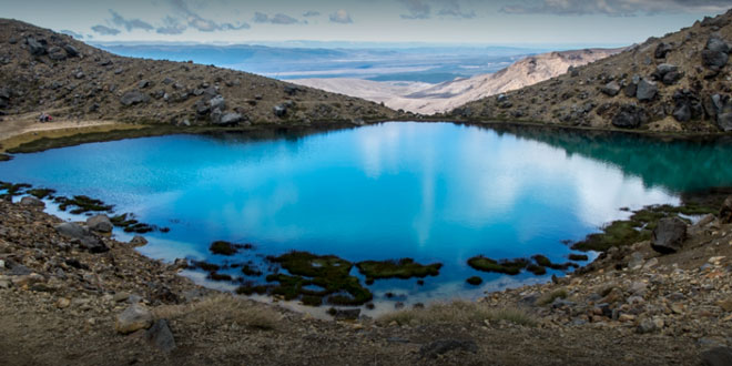
Tongariro National Park was the fourth national park established in the world. The active volcanic mountains Ruapehu, Ngauruhoe, and Tongariro are located in the centre of the park.
There are a number of Māori religious sites within the park and many of the park’s summits, including Ngauruhoe and Ruapehu, are tapu, or sacred. The park includes many towns around its boundary including Ohakune, Waiouru, Horopito, Pokaka, Erua, National Park Village, Whakapapa skifield and Turangi.
The Tongariro National Park is home to the famed Tongariro Alpine Crossing, widely regarded as one of the world’s best one-day hikes.
Tongariro National Park covers approximately 795.98 km2 stretching between 175° 22′ and 175° 48′ East and 38° 58′ and 39° 25′ South in the heart of the North Island of New Zealand. It is just a few kilometres west-southwest of Lake Taupo. It is 330 km south of Auckland by road, and 320 km north of Wellington. It contains a considerable part of the North Island Volcanic Plateau. Directly to the east stand the hills of the Kaimanawa range. The Whanganui River rises within the park and flows through Whanganui National Park to the west.
Most of the park is located in the Ruapehu District (Manawatu-Wanganui Region), although the northeast is in the Taupo District (Waikato Region, or Hawke’s Bay region to the north).
As a curiosity, their exact antipodes coincide with Cabaneros National Park, in Spain.
User reviewed online profile of Tongariro National Park: Tongariro, Taupo and Ruapehu regions, New Zealand. Plan your adventure holiday to Tongariro National Park armed with information and reviews provided by experts and by users. Find out about when to go, how to get there, what to do, best season to visit, its wildlife, habitat and much more…
What to do in Tongariro National Park:
Wild Life: North Island Brown Kiwi, Kaka, Blue Duck, North Island Fernbird, Double-banded Plover, Karearea, Tui, New Zealand Bellbird, Southern Boobook, Grey Warbler, Fantail, Silvereye, Short-tailed Bat, Long-tailed Bat, Moth, Weta, black Rat, Stoat, Cat, Rabbit, Hare, Possum and Red Deer
Adventure: Trout Fishing, Canoeing, Kayaking, Jet Boating, Mountain Biking, Hunting, Scenic Rail, Sightseeing, Skiing, Snowboarding, Tramping, Camping, Scenic Flights, Quad Biking, Trail-biking
Where is Tongariro National Park:
Region: Located in the central North Island of New Zealand.
Location: Ruapehu and Taupo districts, Tongariro, Taupo and Ruapehu regions, New Zealand
When & how to get to Tongariro National Park:
Best Time to Visit: 01-Nov to 31-May
Getting There: The Park is surrounded by well-maintained roads that roughly follow the park borders and provide easy access. In the west, State Highway 4 passes National Park village, and in the east, State Highway 1, known for this stretch as the Desert Road, runs parallel to the Tongariro River. State Highway 47 joins these two highways to the north. The southern link is State Highway 49.
Nearest Town: National Park
Nearest Airport: Waiouru
Nearest Railway Station: National Park
Where to stay (Lodges / Guest Houses / Camps / Resorts / Hotels):
Accommodation: The walk known as the Tongariro Northern Circuit is served by four Department of Conservation ‘Great Walk’ huts. DOC also has a number of ‘Serviced’ and ‘Basic’ huts in other parts of the park. At Whakapapa village there are campsites and cabins as well as motels and resort hotels. Various types of accommodation can be found in and around the towns Turangi, National Park Village and Ohakune.
Add a hotel: If you know of a hotel, resort, guest house or camp please add it here. If you own or manage a hotel or resort you can add it to the database for ‘Free’.
Climate & Weather conditions in Tongariro National Park:
Temp: 10 c to 25 c
Rainfall: 2200 cm
Altitude: 1119 m
Other details about Tongariro National Park:
Established: 1887
Area: 796 sq km
Language: English and Maori
 ITP Indian Travel Places: Food, Travel, Tourism Business Events and Trade Shows
